Tried to moor in-between but there were 2 problems:
The railway track: Not more than 20 yards from the canal bank. Great news if you like to be waking up with a train going past your head at 3 o’clock in the morning. Otherwise, not a good spot for mooring.
Heavy growth of giant hogweed; and other plantlife dipping quite heavily into the canal on a cambered bank. Making it quite hard for mooring.
Didn’t bother, after spending and hour or so wondering round seeing if I could find a suitable spot.
Felt a bit bored. Took a walk to Ham and Ham Spray.
Again, walked up through the estates of Little Bedwyn, with the ‘beware u will be shot’ signs, on to somewhere called ‘Prospero’ estates, again with little ‘u will be shot’ signs, but better hidden.
Saw lots of little birds and beasties along the way, including a weasel and about 5 hares.
Savernake forest
The woods are near Savernake forest which is owned by the Earl of Cardigan and is some 4.500 acres. I visited Savernake forest on Sunday, it’s possible to drive through from to Marlborough almost.
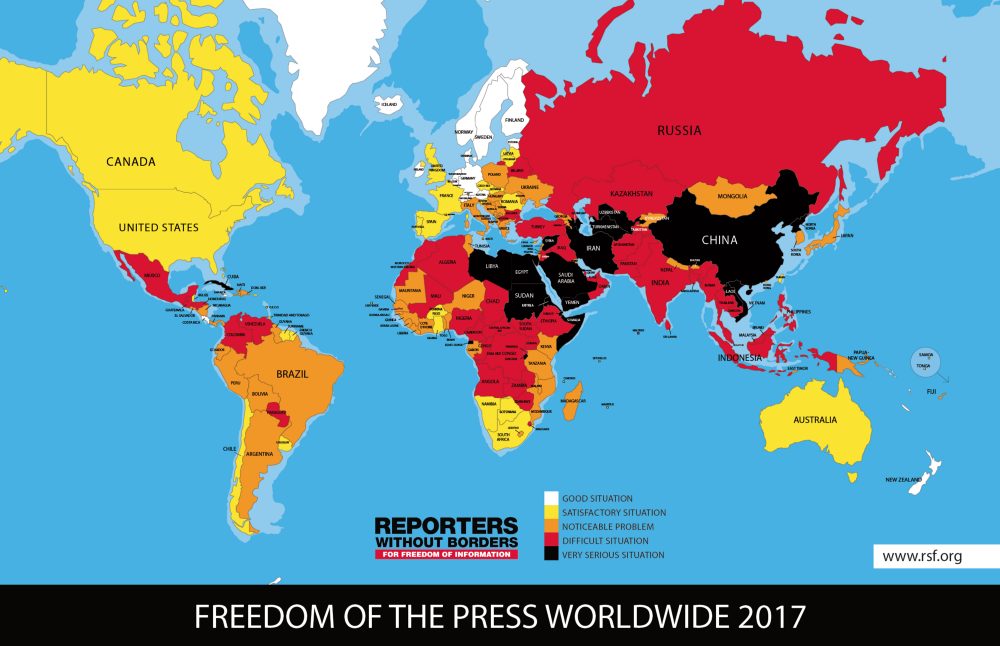
[su_pullquote align=”right”]Global press freedom declined to its lowest point in 13 years in 2016 amid unprecedented threats to journalists and media outlets in major democracies and new moves by authoritarian states to control the media, including beyond their borders.[/su_pullquote]
Censorship is another indicator of declining press freedom, and governments and other actors are finding new ways to promote repression, many of which compromise the necessity of an open internet. The CPJ analyzes countries to determine their status using a series of benchmarks, including:
the absence of privately owned or independent media,
blocking of websites,
restrictions on electronic recording and dissemination,
license requirements to conduct journalism,
restrictions on journalists’ movements,
monitoring of journalists by authorities,
jamming of foreign broadcasts, and
blocking of foreign correspondents.
The resulting list of the 10 Most Censored Countries includes Eritrea, North Korea, Saudi Arabia, Ethiopia, Azerbaijan, Vietnam, Iran, China, Myanmar, and Cuba.
We use cookies on our website to give you the most relevant experience by remembering your preferences and repeat visits. By clicking “Accept All”, you consent to the use of ALL the cookies. However, you may visit "Cookie Settings" to provide a controlled consent.
This website uses cookies to improve your experience while you navigate through the website. Out of these, the cookies that are categorized as necessary are stored on your browser as they are essential for the working of basic functionalities of the website. We also use third-party cookies that help us analyze and understand how you use this website. These cookies will be stored in your browser only with your consent. You also have the option to opt-out of these cookies. But opting out of some of these cookies may affect your browsing experience.
Necessary cookies are absolutely essential for the website to function properly. These cookies ensure basic functionalities and security features of the website, anonymously.
Cookie
Duration
Description
cookielawinfo-checkbox-analytics
11 months
This cookie is set by GDPR Cookie Consent plugin. The cookie is used to store the user consent for the cookies in the category "Analytics".
cookielawinfo-checkbox-functional
11 months
The cookie is set by GDPR cookie consent to record the user consent for the cookies in the category "Functional".
cookielawinfo-checkbox-necessary
11 months
This cookie is set by GDPR Cookie Consent plugin. The cookies is used to store the user consent for the cookies in the category "Necessary".
cookielawinfo-checkbox-others
11 months
This cookie is set by GDPR Cookie Consent plugin. The cookie is used to store the user consent for the cookies in the category "Other.
cookielawinfo-checkbox-performance
11 months
This cookie is set by GDPR Cookie Consent plugin. The cookie is used to store the user consent for the cookies in the category "Performance".
viewed_cookie_policy
11 months
The cookie is set by the GDPR Cookie Consent plugin and is used to store whether or not user has consented to the use of cookies. It does not store any personal data.
Functional cookies help to perform certain functionalities like sharing the content of the website on social media platforms, collect feedbacks, and other third-party features.
Performance cookies are used to understand and analyze the key performance indexes of the website which helps in delivering a better user experience for the visitors.
Analytical cookies are used to understand how visitors interact with the website. These cookies help provide information on metrics the number of visitors, bounce rate, traffic source, etc.
Advertisement cookies are used to provide visitors with relevant ads and marketing campaigns. These cookies track visitors across websites and collect information to provide customized ads.