
This post describes how to create Google Maps from a GPS devise.
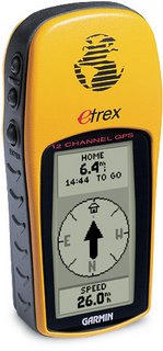
Your Etrex will output two lots of data available from the GPX files.
The two types of data allow you to create.
A Google Map of Waypoints
A Google Map of Tracks
There is a process you need to follow:-
Plug in your GPS unit.
Access Ozi Explorer.
Use the interface to import your waypoints..
A Google Map of Waypoints
1) Ozi Explorer
Get Waypoints from GPSFile > Save Maps to File > Export to GPX – Save to Desktop
2) GPS Visualizer
You’ve got a selection of options.In order to get them into Google Maps, they have to be in a web accessible format. So choose Google Earth format.
Once your file is uploaded you should be given a link to download your file which looks something like this 1211203282-21568-82.37.19.123.kmz.
Click on it get it to your desktop.
3) Googlemaps
Go to Googlemaps.co.ukGo to My Maps
On Create New Map > Import > KML File
A Google Map of Tracks
… lifted straight from previous blogs on the subject.
1) Ozi Explorer
From the interface > Get track from GPSIf you’ve done it correctly, you’ll get a tally in the toolbar.
Wait until this has finished.
File > Save Maps to File > Export to GPX – Save to Desktop
2) GPS Visualizer
Again, you’ve got a selection, choose Google Earth and your file will convert to a web-ready format.From your link, 1211203282-21568-82.37.19.123.kmz, save to desktop.
3) Googlemaps
Go to Googlemaps.co.ukGo to My Maps
On Create New Map > Import > KML File.
If the file is a large one Maps will split it up over a number of pages.
That’s it! Google plots your waypoints/tracks then zooms to center the map.
It’s as simple as giving your waypoints/tracks some names and you can share this map with the world.
Hardware
Garmin Etrex GPS
Garmin PC interface cable (RS232 serial port connector) – not applicable to Geko 101
Related Reading
If you’re planning a trip, or maybe living there as an expat, these are the apps you’re going to want to have installed to your...
So….. Turns out the NHS, Fedex and a number of other companies and organisations have been hit by this same Ransomwear virus. According to Avast,...

If you ever thought moving to another planet was a good idea, here’s a reason why. TPP is being negotiated in secret by governments of...

Top 14 tips for Amazon Flex drivers (UK). Map of Amazon Flex depots. Amazon Flex contract for drivers.

This is a short guide to installing flexible solar panels to a narrowboat. How long do flexible solar panels last for? No doubt, less long...

Why not skip Step #3 by just having GPS Visualizer create a Google Map instead of KML?
Probably because the visualiser ‘Map’ option renders in javascript.
When you take this to another platform you have to output directly to code. Doing it through KML/google maps means it’s accessible to any user on any platform and you don’t have to mess around with web-pages.
The newer versions of ozi explorer output directly to KML.
In this example I’ve used visualiser. In future, I might not need to.
Thanks for your comment
Is there a way to create a google map, export to kml, convert to gpx and import to the etrex?
Best GPS Accessories on the Net. http://bestgpsmarket.com